North India to burn, South to be drenched: What Wednesday's weather looks like
The seasonal rains that irrigate India's farms and fill its reservoirs are advancing steadily and are expected to set in over Kerala several days ahead of the usual June 1 date.
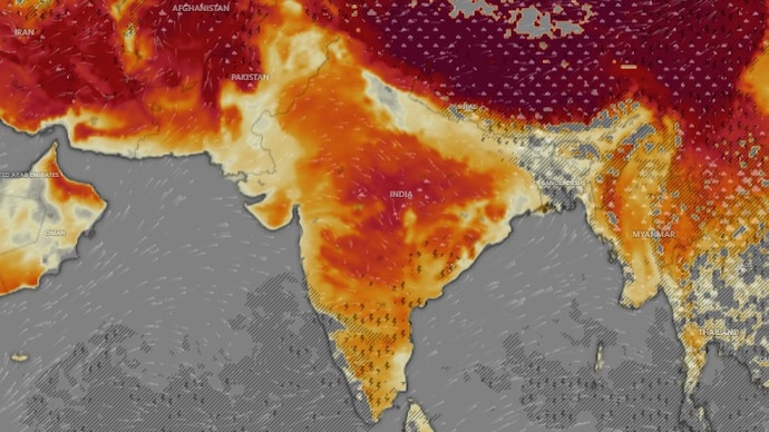
Tuesday, May 19, turned out to be one of the most punishing days of the year for north and central India.
Banda in Uttar Pradesh recorded a searing 47.6°C, already higher than yesterday's national high of 46.4°C at the same location, as heat wave to severe heat wave conditions gripped East Uttar Pradesh, Madhya Pradesh, Vidarbha, West Uttar Pradesh, and Rajasthan.
Even the overnight lows brought no real relief, with night temperatures running more than 5°C above normal in parts of East Rajasthan, East Uttar Pradesh, Haryana, Delhi, Jammu & Kashmir, and Vidarbha.
The lowest minimum anywhere on the plains was 22.8°C at Rohtak in Haryana, warm enough to make sleep difficult.
Meanwhile, on the other end of the country, Kerala received the most widespread rain of any region, with Tamil Nadu's Kanyakumari district recording 16 cm of rainfall in a single day at Neyyoor.
Hailstorms were also reported at isolated places in Odisha.
And it's not over yet. The contrasting weather between different regions across India is expected to continue on Wednesday, May 20.
HOW WILL THE WEATHER BE ON WEDNESDAY?
Wednesday will bring more of the same two-India story.
The north will remain under an intense heat dome, with Haryana, Delhi, Punjab, Madhya Pradesh, Uttar Pradesh, and Vidarbha all on alert for heat wave to severe heat wave conditions.
Several parts of Delhi and Punjab are also expected to face severe heat wave, with warnings issued for May 20.
To make it worse, relief is still a bit distant. Temperatures are not expected to fall significantly across most of the country through May 25.
Meanwhile, in the east, strong thundersqualls with winds reaching 50–60 kmph are expected at isolated places in Andhra Pradesh, Bihar, Gangetic West Bengal, Jharkhand, and Odisha.
Kerala and Lakshadweep will continue to see widespread to heavy rain, with coastal Karnataka also receiving scattered showers, signalling the arrival of monsoon.
Odisha will experience hot and humid conditions alongside the risk of thundersqualls.
MONSOON MOVES CLOSER
Through all this heat and rain, the bigger story brewing in the background is the southwest monsoon.
The seasonal rains that irrigate India's farms and fill its reservoirs are advancing steadily. They are expected to be set in Kerala around May 26, several days ahead of the normal June 1 date.
Conditions over the next 3–4 days remain favourable for the monsoon to push further into the Arabian Sea, Bay of Bengal, and Andaman Sea.
For much of the country still sweltering under relentless heat, that arrival cannot come soon enough.
Tuesday, May 19, turned out to be one of the most punishing days of the year for north and central India.
Banda in Uttar Pradesh recorded a searing 47.6°C, already higher than yesterday's national high of 46.4°C at the same location, as heat wave to severe heat wave conditions gripped East Uttar Pradesh, Madhya Pradesh, Vidarbha, West Uttar Pradesh, and Rajasthan.
Even the overnight lows brought no real relief, with night temperatures running more than 5°C above normal in parts of East Rajasthan, East Uttar Pradesh, Haryana, Delhi, Jammu & Kashmir, and Vidarbha.
The lowest minimum anywhere on the plains was 22.8°C at Rohtak in Haryana, warm enough to make sleep difficult.
Meanwhile, on the other end of the country, Kerala received the most widespread rain of any region, with Tamil Nadu's Kanyakumari district recording 16 cm of rainfall in a single day at Neyyoor.
Hailstorms were also reported at isolated places in Odisha.
And it's not over yet. The contrasting weather between different regions across India is expected to continue on Wednesday, May 20.
HOW WILL THE WEATHER BE ON WEDNESDAY?
Wednesday will bring more of the same two-India story.
The north will remain under an intense heat dome, with Haryana, Delhi, Punjab, Madhya Pradesh, Uttar Pradesh, and Vidarbha all on alert for heat wave to severe heat wave conditions.
Several parts of Delhi and Punjab are also expected to face severe heat wave, with warnings issued for May 20.
To make it worse, relief is still a bit distant. Temperatures are not expected to fall significantly across most of the country through May 25.
Meanwhile, in the east, strong thundersqualls with winds reaching 50–60 kmph are expected at isolated places in Andhra Pradesh, Bihar, Gangetic West Bengal, Jharkhand, and Odisha.
Kerala and Lakshadweep will continue to see widespread to heavy rain, with coastal Karnataka also receiving scattered showers, signalling the arrival of monsoon.
Odisha will experience hot and humid conditions alongside the risk of thundersqualls.
MONSOON MOVES CLOSER
Through all this heat and rain, the bigger story brewing in the background is the southwest monsoon.
The seasonal rains that irrigate India's farms and fill its reservoirs are advancing steadily. They are expected to be set in Kerala around May 26, several days ahead of the normal June 1 date.
Conditions over the next 3–4 days remain favourable for the monsoon to push further into the Arabian Sea, Bay of Bengal, and Andaman Sea.
For much of the country still sweltering under relentless heat, that arrival cannot come soon enough.

