


India has more cities than it knows of. Why are they hiding in plain sight?
India might have far more cities and towns than the government's numbers acknowledge. An EAC-PM paper argues that millions live in human settlements that function like towns and cities but officially remain classified as rural. This adversely impacts the lives of millions of residents.
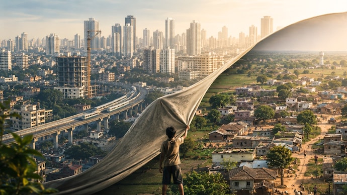
Towns and cities in India are passing off as villages due to statistical and policy constraints. (Image: AI/Sushim Mukul)
New Delhi,UPDATED: May 27, 2026 09:03 IST
Are there other Lucknow, Pune and Rajkot than we know of? India might have far more cities than the government's numbers acknowledge. A working paper released by the Economic Advisory Council to the Prime Minister (EAC-PM) argues that India's actual level of urbanisation is significantly higher than what government data suggests. The paper says it impacts the residents because panchayats are forced to deal with urban issues, like waste management and traffic, that they aren't equipped to handle.
Titled India's Hidden Urbanisation & Its Policy Implications, the paper by EAC-PM member Shamika Ravi and consultants Manuj Joshi and Apurv Kumar Mishra contends that millions of Indians live in settlements that function like towns and cities but remain officially classified as rural.
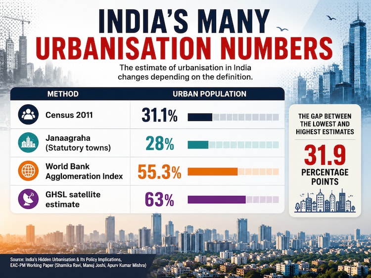
According to Census 2011, only 31.1% of Indians lived in urban areas. But the paper cites satellite-based estimates showing India might already have been 63% urban in 2015.
The authors of the paper warn that the gap between administrative labelling and the ground realities is distorting governance, public spending and infrastructure planning.
The debate has acquired fresh relevance because the Registrar General of India has proposed retaining the 2011 definition of urban areas for Census 2027 to ensure comparability across decades. The authors of the paper, however, argue that India's urban transition has outpaced the urban-rural definitions devised half a century ago.
The concern over hidden urbanisation or hidden urban sports in India is not entirely new. The World Bank's Agglomeration Index (published in 2015), developed by economists Uchida Hirotsugu and Andrew Nelson, estimated that 55.3% of India's population was already living in urban-like areas in the 2010s. It highlighted that a large degree of "hidden urbanisation" was beyond legal city limits.
INDIA'S CITIES ARE HIDING IN PLAIN SIGHT? BUT HOW?
The EAC-PM paper's central argument is that India is urbanising much faster than its administrative systems are recognising cities and towns.
It notes that the classification of human settlements as urban or rural determines governance structures, eligibility for schemes and allocation of public resources. Yet many places that have urban characteristics (factories, shops, offices, transport, construction or services rather than farming) remain officially rural.
"Misclassification of 'urban' and 'rural' has serious consequences: it undermines targeted policy formulation, misallocates public resources, and masks the real scale of India's urban transition," notes the paper.
"Policymakers often work on the faulty assumption that 'rural' is a proxy for 'poor' and accordingly spend greater resources on provisioning of public goods in areas defined as 'rural'," it adds.
The paper points out that state governments notify statutory towns, while the Census separately identifies "census towns".
A settlement qualifies as a census town if it has a population above 5,000, a density above 400 persons per sq km, and at least 75% of the male working population is engaged in non-agricultural activities. Many such settlements continue to be administered as villages despite functioning as urban spaces, the paper notes.
As a result, India has large numbers of places that look urban, work urban and earn urban incomes, but remain rural on paper.
HOW URBAN IS INDIA REALLY?
The answer to how urban India is depends on which definition one uses.
According to the EAC-PM paper, only 31.1% of Indians were officially urban in Census 2011.
However, research cited by the authors paints a very different picture. In the paper, they cite a study by Janaagraha Foundation, a think tank, which estimates that 28% of Indians lived in statutory towns in 2024.
But satellite-based measurements from the Global Human Settlement Layer (GHSL) suggest India was already 63% urban in 2015.
"What is beyond doubt is that the current classification, which uses a combination of administrative definition and census criteria, is inadequate in capturing the speed and scale of urbanisation in India," the EAC-PM paper notes.
The Economic Survey 2025-26 cited in the paper highlighted Kerala as an example. While statutory urbanisation in the state is estimated at about 54%, the figure rises to nearly 81% when spatially identified settlements are included.
WHAT DID THE WORLD BANK'S AGGLOMERATION INDEX FIND?
Long before satellite-based urbanisation estimates became popular, the World Bank attempted to measure urbanisation in India through a different lens.
The Agglomeration Index classified areas using three variables. They were, population density, proximity to a large urban centre and travel time to that centre. Using this methodology, India was estimated to be 55.3% urban as early as 2010.
The findings suggested that urbanisation extended well beyond municipal boundaries and official city limits.
The recent EAC-PM paper cites the estimate to demonstrate that India's urban footprint has been underestimated for years. It also notes that global frameworks such as DEGURBA, endorsed by the UN in 2020, increasingly rely on satellite imagery and population grids rather than administrative labels alone to identify urban settlements.
WHY DOES CENSUS 2027 MATTER?
The quantification of India's urbanisation carries significance because Census 2027, the first digitally conducted population computing exercise, is expected to retain the same definition used in Census 2011.
"The definition of a census town has not changed since 1971 and the 2027 census plans to continue with the same definition," the paper notes.
For the authors of the EAC-PM paper, that is a major limitation in sticking to the old method.
The requirement that 75% of the male workforce be engaged in non-agricultural work reflects an economy very different from what is present in today's India, where informal services, platform work, commuting patterns and mixed livelihoods blur the traditional rural-urban divide.
The paper therefore calls for a more dynamic framework incorporating technology, occupation patterns and updated population data rather than relying primarily on decadal census exercises.
WHY IS HIDDEN URBANISATION A GOVERNANCE PROBLEM?
The authors of the EAC-PM paper argue that undercounting urbanisation has an adverse impact on policy formulation, execution and implementation.
Many fast-growing human settlements in India continue to be governed by panchayats designed for rural administration even though they face urban challenges such as traffic congestion, sewage treatment, waste management and housing demand. Therefore, they require urban governance institutions with the authority and resources to tackle issues such as traffic, sanitation, waste management and housing.
"Large parts of the country which are de facto urban, continue to be governed by rural local bodies with limited capacity and powers," the paper says.
It cites the example of Gurugram as a warning. Despite becoming a major economic hub, the city lacked a municipal corporation until 2008 and subsequently struggled with waterlogging, mobility bottlenecks and planning deficiencies.
In fact, Gurugram loses its tag Millennium City, come monsoon.
The paper also references a NITI Aayog report that warned, "With business as usual, the country may become a haven for unplanned urbanisation."
WHAT IS THE SOLUTION TO INDIA'S HIDDEN URBANISATION?
Rather than waiting for every census cycle, the authors propose using daytime satellite imagery to measure "built-up volume". It is a metric combining the extent and height of physical structures such as buildings and infrastructure.
"Therefore, we recommend usage of daytime satellite data to measure built-up volume as a modern source for mapping the state of urbanisation and the average size of urban conglomerates," says the paper.
The paper also calls for automated "trigger mechanisms" that would reclassify settlements from rural to urban once they cross objective thresholds.
"A structured approach towards urbanisation is one of the most important requirements towards growth of India towards a Viksit Bharat as well as prevent many of the modern issues accompanied by unplanned development," note the authors of the paper.
The paper's broader message is that India should stop measuring urbanisation solely through population-based administrative labels and start recognising what satellite images, economic activity and lived reality reveal. So, the gist of the story is that many of India's new cities and towns are no longer waiting to emerge. They are already there, hiding in plain sight. And that's not good for the residents there.
- Ends