
Cyclonic vortex brews off Kerala coast, pre-monsoon rain to intensify on Wednesday
A cyclonic vortex has formed off the Kerala coast, boosting rain and thunderstorm activity. The system could aid the southwest monsoon onset over Kerala within 72 hours.
")

A fresh weather system developing over the Arabian Sea could finally pave the way for the southwest monsoon to arrive over Kerala, even as thunderstorms continue to lash several parts of India and heatwave conditions intensify in the east.
Analysis of the latest INSAT-3DS satellite imagery from Tuesday shows widespread convective cloud activity over northwestern India, parts of central India, and the northeastern states.
Dense cloud clusters are visible over Jammu & Kashmir, Himachal Pradesh, Uttarakhand and adjoining regions, indicating active thunderstorm development. Scattered thunderclouds are also present across peninsular India and the Bay of Bengal.
The most significant development, however, lies off the Kerala coast, where a mid-level cyclonic vortex has formed over the southeastern Arabian Sea. Meteorologists say the system is likely to enhance moisture transport towards the southwest coast and increase pre-monsoon thunderstorm activity over Kerala and south Karnataka during the next few days.
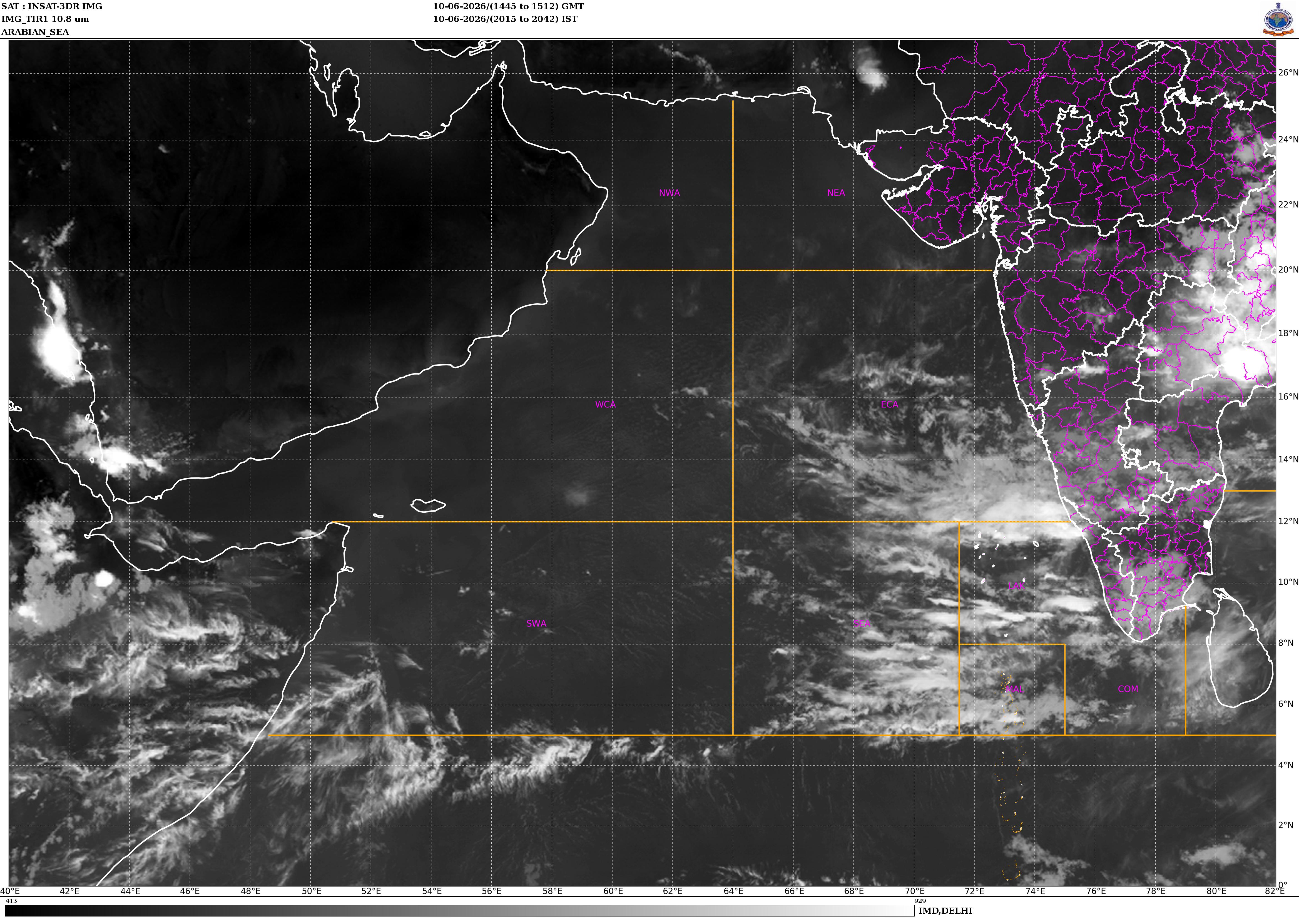
As the vortex gradually moves northward, atmospheric conditions are expected to become increasingly favourable for the onset of the southwest monsoon over Kerala within the next 72 hours. The system is helping organize cloud bands and strengthen low-level westerly winds, two key ingredients required for monsoon onset.
For Wednesday, residents of Kerala and coastal Karnataka can expect frequent spells of rain accompanied by thunderstorms, lightning and gusty winds. Some locations may witness heavy rainfall, especially along the Western Ghats.
Thunderstorm activity is also expected to remain widespread across northwest, central and eastern India. Delhi-NCR, Rajasthan, Haryana, Punjab, Madhya Pradesh, Chhattisgarh, Jharkhand and parts of Uttar Pradesh could experience isolated thunderstorms, lightning and strong winds, providing intermittent relief from summer heat.
The satellite image further indicates extensive cloud cover stretching across northeastern India. Accordingly, Assam, Meghalaya, Arunachal Pradesh, Nagaland, Manipur, Mizoram and Tripura are likely to witness humid conditions along with scattered rain and thunderstorms.
While many parts of the country enjoy cooler weather due to cloud cover and rainfall, Bihar is set to remain an exception.
The India Meteorological Department (IMD) has warned that heatwave conditions are likely to prevail across the state from June 4 to June 6. Daytime temperatures are expected to remain significantly above normal, increasing heat stress risks.
Hot and humid weather is also forecast over Sub-Himalayan West Bengal and Sikkim, Assam and Meghalaya, Konkan and Goa, Odisha, Arunachal Pradesh and several northeastern states during the coming days.
With a cyclonic vortex strengthening off Kerala and widespread thunderstorm activity already underway across the country, weather experts believe India may be on the verge of a long-awaited monsoon onset.
The next three days will be crucial in determining how quickly the rain-bearing winds advance inland and bring relief to millions awaiting the arrival of the rainy season.