Storms, hail and heat: Friday to experience turbulent weather
After a day of heat, thunderstorms, strong winds and hail across parts of North India, the weather is set to remain volatile on Friday. Here's a detailed forecast for what to expect tomorrow.
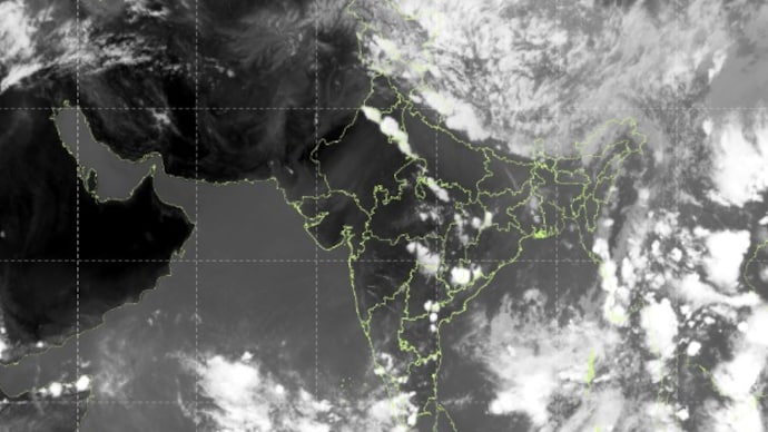
May 28 turned out to be a turbulent day across much of North India.
Delhi-NCR, Punjab, and Haryana were hit by intense thunderstorms accompanied by strong, gusty winds.
Parts of Delhi-NCR also faced the unusual combination of a thunderstorm and a hailstorm simultaneously, while heat wave conditions continued to grip the region during the day.
Maximum temperatures across Northwest India remained markedly above normal, and the highest temperature recorded anywhere in the country was a scorching 47.4°C in Banda, Uttar Pradesh.
HOW WILL THE WEATHER BE ON FRIDAY?
Friday is not expected to offer much relief.
The India Meteorological Department (IMD), the government body responsible for weather forecasting in India, has warned that Delhi-NCR and neighbouring areas of Punjab and Haryana can expect another round of heavy rainfall, thunderstorms, and hailstorms.
Winds could gust between 60–70 kmph, an intense level capable of inflicting damage. Waterlogging in low-lying urban areas and traffic disruption are likely consequences residents should prepare for.
Despite the rain and storms, heatwave conditions are forecast to persist on May 29 across parts of Madhya Pradesh, Telangana, and coastal Andhra Pradesh.
West Rajasthan faces an even grimmer outlook, with severe heatwave conditions likely, where temperatures can climb well above 45°C.
IMD has advised people in these areas to stay indoors during peak afternoon hours, stay hydrated, and avoid prolonged Sun exposure.
MONSOON MAKING PROGRESS
All eyes are also on the advancing southwest monsoon, India's life-giving seasonal rainfall system that typically arrives in Kerala in early June and gradually covers the entire country by mid-July.
Currently, the monsoon has reached the southern tip of the country and nearby seas, after experiencing a brief delay due to cyclonic activity in the Bay of Bengal.
The IMD has confirmed that conditions are favourable for the monsoon to advance further into the Arabian Sea and Bay of Bengal over the next two to three days.
Delhi-NCR typically receives the monsoon around late June, so residents have a few more weeks to wait before sustained relief arrives.
Early signs are emerging and signalling the beginning of the end of what has been an unrelenting summer.
May 28 turned out to be a turbulent day across much of North India.
Delhi-NCR, Punjab, and Haryana were hit by intense thunderstorms accompanied by strong, gusty winds.
Parts of Delhi-NCR also faced the unusual combination of a thunderstorm and a hailstorm simultaneously, while heat wave conditions continued to grip the region during the day.
Maximum temperatures across Northwest India remained markedly above normal, and the highest temperature recorded anywhere in the country was a scorching 47.4°C in Banda, Uttar Pradesh.
HOW WILL THE WEATHER BE ON FRIDAY?
Friday is not expected to offer much relief.
The India Meteorological Department (IMD), the government body responsible for weather forecasting in India, has warned that Delhi-NCR and neighbouring areas of Punjab and Haryana can expect another round of heavy rainfall, thunderstorms, and hailstorms.
Winds could gust between 60–70 kmph, an intense level capable of inflicting damage. Waterlogging in low-lying urban areas and traffic disruption are likely consequences residents should prepare for.
Despite the rain and storms, heatwave conditions are forecast to persist on May 29 across parts of Madhya Pradesh, Telangana, and coastal Andhra Pradesh.
West Rajasthan faces an even grimmer outlook, with severe heatwave conditions likely, where temperatures can climb well above 45°C.
IMD has advised people in these areas to stay indoors during peak afternoon hours, stay hydrated, and avoid prolonged Sun exposure.
MONSOON MAKING PROGRESS
All eyes are also on the advancing southwest monsoon, India's life-giving seasonal rainfall system that typically arrives in Kerala in early June and gradually covers the entire country by mid-July.
Currently, the monsoon has reached the southern tip of the country and nearby seas, after experiencing a brief delay due to cyclonic activity in the Bay of Bengal.
The IMD has confirmed that conditions are favourable for the monsoon to advance further into the Arabian Sea and Bay of Bengal over the next two to three days.
Delhi-NCR typically receives the monsoon around late June, so residents have a few more weeks to wait before sustained relief arrives.
Early signs are emerging and signalling the beginning of the end of what has been an unrelenting summer.

