
Heavy rain, dust storm hit Delhi-NCR, bring much-needed relief from heat
After days of brutal heatwave conditions, dust storms, gusty winds and rain swept across Delhi-NCR on Thursday evening, bringing a sharp temperature drop even as IMD warned of more thunderstorms and hail through the night.


After days of relentless heatwave conditions, strong winds, dust storms and rain lashed several parts of Delhi-NCR on Thursday evening, bringing much-needed relief to residents struggling through temperatures touching 44-46°C.
Dark clouds covered the sky across Delhi as gusty winds swept through the city before rainfall began in several areas. The sudden weather change led to a sharp dip in temperatures and brought respite from the exhausting heat that had gripped the region for days.
The India Meteorological Department (IMD) had earlier issued an orange alert for Delhi and Noida and a red alert for Gurugram, warning of moderate to severe thunderstorms, lightning, isolated hailstorms and strong winds reaching 60–80 kmph.
Meteorologists had earlier predicted intensifying weather activity moving towards Delhi-NCR from the Rajasthan-Haryana belt. The system brought dust storms followed by moderate rain, thunder and lightning across multiple areas.
Temperatures are now expected to fall by 7°C-10°C from recent highs.
The heatwave had pushed daytime temperatures to extreme levels while nights remained unusually warm, with some places recording May minimum temperatures above 32°C. The conditions had also increased power demand and made outdoor movement difficult across the region.
STORM ACTIVITY ACROSS NORTH INDIA
The weather system moved eastward from Rajasthan and Haryana towards Delhi-NCR, with satellite images showing dense cloud formations stretching towards Agra and nearby regions.
According to the IMD, thunderstorms, rain and gusty winds are also likely across parts of Haryana, Punjab, Chandigarh and western Uttar Pradesh through the evening and night.
Officials have advised residents to stay indoors during intense thunderstorm activity and avoid unnecessary travel during periods of low visibility caused by dust storms.
While the rain spell may not mark the onset of the monsoon, it has brought a much-needed break from the scorching summer conditions that dominated north India through much of May.
AIRPORT ISSUES WEATHER ADVISORY
Amid the thunderstorms and rain activity across Delhi-NCR, Delhi International Airport Limited (DIAL) also warned of possible disruptions to flight operations because of deteriorating weather conditions.
In a post on X, DIAL said, “Due to inclement weather conditions and expected thunderstorms in Delhi, some flights might be impacted at Delhi Airport.”
Passengers were advised to check updated flight schedules directly with airlines before heading to the airport.
“Passengers are requested to contact the airline concerned for updated flight information. Passengers can consider alternative modes of transport, including the Delhi Metro, to get to the Airport to avoid potential delays,” the advisory said.
WHAT PLACES WILL COOL DOWN?
As of 4:00 pm on May 28, the IMD noted that light to moderate rainfall with thunderstorms, lightning, and gusty winds of 30–50 kmph is expected across Delhi-NCR, parts of Haryana including Rohtak and Rewari, and areas of Rajasthan such as Alwar over the next two hours.
Delhi-NCR is expected to see the main impact between 6:15 pm and 9 pm, with 60–80% of the area likely affected. Strong winds may stir up dust first, reducing visibility, so secure loose items, close windows, and avoid unnecessary travel during the peak.
The rain should bring quick relief, and will be followed by thunder and lightning that will provide the event with more intensity.
Before the storms reach Delhi-NCR, effects will first be felt in Haryana, from around 4:30 pm to 9:30 pm, covering significant parts of the state.
Punjab could see storms between 5:30 pm and 10 pm, while Chandigarh is likely to experience full impact from 8 pm onward into the night.
In Uttar Pradesh, western and southwest districts may have activity from 5 pm to 11 pm, with northwest areas affected later, from 8 pm to 1 am.
Timings can shift slightly by location, so staying updated with local alerts is important.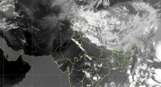
This evening’s weather shift won’t mark the full end of summer, but it should ease the intense heat that has gripped the region.
While the official monsoon onset has been delayed, a preview, marked by strong winds, lightning and some rain will have to make do.
Cooler gusts of winds are on the way, and after the recent heat spell many have endured, a refreshing change is just hours away.