Rain coming: Satellite captures 2,500-km-wide cloud band on its way to India
INSAT-3DS imagery shows a vast cloud band spreading across north and central India. The build-up points to approaching thunderstorms and possible relief after an intense heatwave.
Northern India continued to sizzle under blistering heat on Thursday as the world marked Eid, a day after Rajasthan's Sri Ganganagar recorded the highest temperature in the world at 48.2 degrees Celsius. But relief is around the corner.
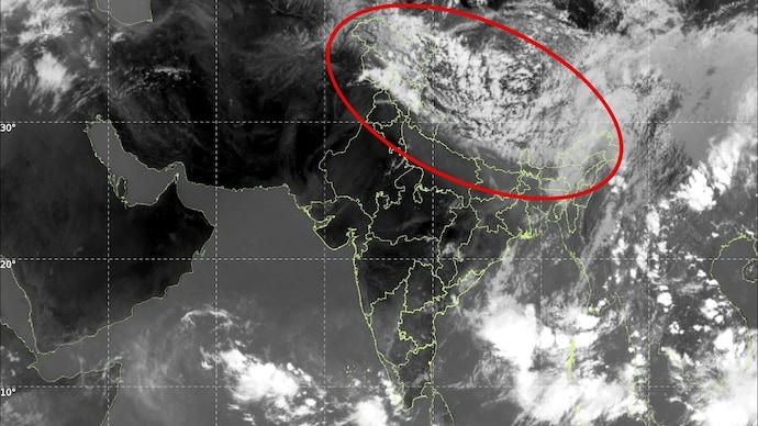
A massive cloud band stretching across large parts of north and central India is currently visible in the latest thermal infrared imagery captured by India’s INSAT-3DS weather satellite, signalling an active build-up of rain-bearing systems over the subcontinent.
The dense cloud band seen in the satellite image extends from Pakistan and northwest India across Punjab, Haryana, Delhi, Uttar Pradesh and parts of central India before merging into cloud clusters over eastern India and the Bay of Bengal.
Meteorologists say the structure appears to be associated with a combination of a western disturbance interacting with moisture incursion from the Arabian Sea and Bay of Bengal.
The cloud mass could be stretching well over 2,000 to 2,500 kilometres across northern India when viewed from west to east, making it one of the more expansive pre-monsoon cloud formations observed this season.
The brightest white regions in the infrared image indicate extremely cold cloud tops, a sign of towering thunderstorm systems rising high into the atmosphere. Such cloud-top temperatures are often associated with intense convection capable of producing heavy rain, thunderstorms, hailstorms and gusty winds.
The satellite imagery also shows a distinct cyclonic swirl over northern Pakistan and the adjoining Jammu and Kashmir region.
This circulation is likely linked to an active western disturbance moving across the western Himalayas. As the system pulls in moisture from both the Arabian Sea and the Bay of Bengal, it is helping organise widespread clouding over the Indo-Gangetic plains.
Weather experts say the evolving cloud structure indicates strong atmospheric instability over north India after days of intense heatwave conditions across Rajasthan, Delhi, Haryana and parts of central India.
The interaction between hot surface temperatures and incoming moisture often creates explosive thunderstorm development during the pre-monsoon transition period. This process can rapidly build large mesoscale convective systems, giant organised clusters of thunderstorms visible from space as massive cloud shields.
The development comes even as the southwest monsoon continues its gradual advance over the southern seas surrounding India. While the monsoon has not yet reached north India, the increasing cloud activity suggests that moisture transport into the northern plains is intensifying earlier than expected.
According to forecasters, several parts of north India could witness thunderstorms, lightning activity, dust storms and scattered rainfall over the coming days.
Mountain states including Himachal Pradesh, Uttarakhand and Jammu and Kashmir, may also experience moderate to heavy rain under the influence of the western disturbance.
Northern India continued to sizzle under blistering heat on Thursday as the world marked Eid, a day after Rajasthan's Sri Ganganagar recorded the highest temperature in the world at 48.2 degrees Celsius. But relief is around the corner.
A massive cloud band stretching across large parts of north and central India is currently visible in the latest thermal infrared imagery captured by India’s INSAT-3DS weather satellite, signalling an active build-up of rain-bearing systems over the subcontinent.
The dense cloud band seen in the satellite image extends from Pakistan and northwest India across Punjab, Haryana, Delhi, Uttar Pradesh and parts of central India before merging into cloud clusters over eastern India and the Bay of Bengal.
Meteorologists say the structure appears to be associated with a combination of a western disturbance interacting with moisture incursion from the Arabian Sea and Bay of Bengal.
The cloud mass could be stretching well over 2,000 to 2,500 kilometres across northern India when viewed from west to east, making it one of the more expansive pre-monsoon cloud formations observed this season.
The brightest white regions in the infrared image indicate extremely cold cloud tops, a sign of towering thunderstorm systems rising high into the atmosphere. Such cloud-top temperatures are often associated with intense convection capable of producing heavy rain, thunderstorms, hailstorms and gusty winds.
The satellite imagery also shows a distinct cyclonic swirl over northern Pakistan and the adjoining Jammu and Kashmir region.
This circulation is likely linked to an active western disturbance moving across the western Himalayas. As the system pulls in moisture from both the Arabian Sea and the Bay of Bengal, it is helping organise widespread clouding over the Indo-Gangetic plains.
Weather experts say the evolving cloud structure indicates strong atmospheric instability over north India after days of intense heatwave conditions across Rajasthan, Delhi, Haryana and parts of central India.
The interaction between hot surface temperatures and incoming moisture often creates explosive thunderstorm development during the pre-monsoon transition period. This process can rapidly build large mesoscale convective systems, giant organised clusters of thunderstorms visible from space as massive cloud shields.
The development comes even as the southwest monsoon continues its gradual advance over the southern seas surrounding India. While the monsoon has not yet reached north India, the increasing cloud activity suggests that moisture transport into the northern plains is intensifying earlier than expected.
According to forecasters, several parts of north India could witness thunderstorms, lightning activity, dust storms and scattered rainfall over the coming days.
Mountain states including Himachal Pradesh, Uttarakhand and Jammu and Kashmir, may also experience moderate to heavy rain under the influence of the western disturbance.

