
Heavy rains lashes Delhi-NCR along with gusty winds in much-needed heat relief
The heatwave in north India has ended as rain begins to fall across the region. A fresh western disturbance is bringing relief with gusty winds and thunderstorms.
")
Relief has finally arrived in north India as a Western Disturbance brings rain and thunderstorms to the region, breaking the recent heatwave. (Photo: PTI)

The sweltering heat that has gripped North India over the past few days is finally meeting its match.
As of June 4, a fresh Western Disturbance has arrived, bringing the much-anticipated relief of cool, thundery showers to the parched plains.
Rain has already begun to fall across several parts of Delhi, Haryana, and surrounding regions, marking a swift transition from the oppressive heatwave conditions.
Meanwhile, the hills have not remained untouched, with parts of Himachal Pradesh experiencing intense hailstorms that have brought a sudden, icy drop in temperatures across the higher reaches.
UNDERSTANDING THE WESTERN DISTURBANCE
This sudden shift in weather is driven by a phenomenon scientists call a Western Disturbance.
Think of this as a wandering pocket of low pressure that travels all the way from the Mediterranean region, picking up moisture as it journeys eastward.
When this system hits the formidable wall of the Himalayas and encounters the hot, baked land of northwest India, the air becomes unstable.
This instability forces warm, moist air to rise rapidly, cooling down to form towering clouds known as cumulonimbus.
These giants are the engines behind the dramatic thunderstorms, lightning, and gusty winds currently forecast for the region.
These storms typically peak during the evening and night hours when the land surface has had time to heat up throughout the day.
A TALE OF TWO WEATHER SYSTEMS
The interaction between the hot surface of our plains and the incoming cool, moist air from the upper atmosphere acts like a natural cooling system.
While we often think of rain as just water falling from the sky, here it serves as an evaporative cooler, helping to slash those uncomfortable temperatures that have been hovering between 39 and 42 degrees Celsius.
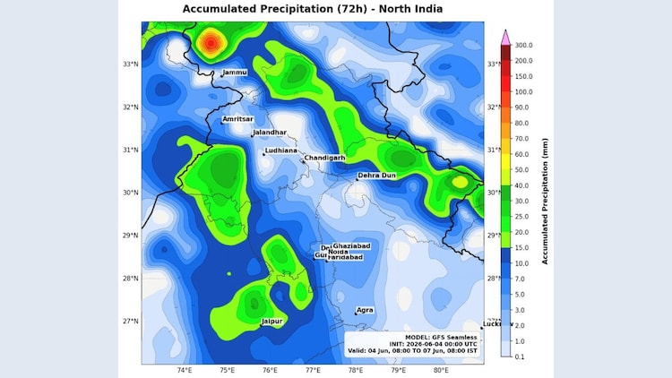
Residents in parts of Delhi, Haryana, Punjab, north Rajasthan, and northwest Uttar Pradesh are already witnessing these scattered storms, which are expected to intensify further during the evening and night hours through June 6.
This spell is expected to bring a much-needed accumulation of 20 to 40 millimetres of rainfall in the most affected pockets.
STAYING SAFE DURING THE SQUALLS
While this rain is a blessing for agriculture and soil moisture, it comes with the classic intensity of pre-monsoon weather.
Expect gusty winds reaching up to 60 kilometres per hour during these storms.
It is important to stay indoors when the lightning intensifies and ensure that any loose items on balconies or rooftops are secured.
This is a temporary but powerful break from the heat, offering a glimpse of the relief the impending monsoon will soon bring to the entire country.
- Ends