

Delhi's forgotten 1,100-year-old dam still tells the story of the Tomars
Tracing the early history of Delhi, the India Today editorial team reached its southernmost edge. Hidden in the Aravallis stands a dam built around 1,100 years ago, a structure that tells the forgotten story of early Delhi and the Tomars, among the region's earliest known rulers. The village of Anangpur was one of the earliest settlements in the area and is believed to have later served as a Tomar capital. This small region carries many layers of history, and what we found there was eye-opening. Join us this week as we uncover this historical treasure.
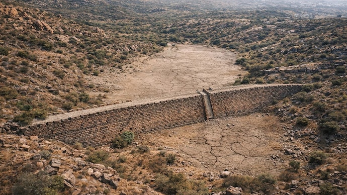
Early Delhi depended on linked water systems such as hauz, baolis and embankments, where water availability depended on seasonal flow and recharge. (Representative image used to show an aerial view of the dam site)

New Delhi,UPDATED: Apr 5, 2026 18:11 IST
Editor’s note: This three-part series, ‘Finding Delhi’s History’, explores the city’s forgotten beginnings hidden along the Aravalli ridge. Long before the Sultanate and Mughal eras, these landscapes shaped Delhi’s earliest settlements. Through on-ground reporting, the series pieces together a past that still survives quietly in the ruins scattered across the Aravallis.
After riding nearly 5 kilometres from the ancient site of Surajkund masonry reservoir on a motorcycle with tripod and mic in hand in search of history, the India Today team’s journey soon gave way to a more difficult passage through broken ground and stony tracks. The road narrowed, the terrain turned harsher, and the undulating ridges of the Aravallis slowly drew in around us. At last, we reached the site, perched on the southernmost entrance to Delhi. Here the ancient city of Indraprastha started reviving, as the last rocky outcrops dissolve into Haryana’s ancient landscape, cradled within low hills.
What stood before us was not merely an old structure, but a 1,100-year-old hydraulic monument, a surviving relic of Delhi’s early medieval past.
The Anangpur Dam lies in quiet repose, nestled amid the rugged Aravalli hills.
The site is believed to have been built in the 10th century CE, when the Tomars were the lords of the region.
The dam is closely tied to one of the earliest known ruling clans of Delhi. The Tomars, who transformed this rugged frontier into a bastion, are believed to have held sway over the region for nearly 419 years, with traditions and historical references pointing to the succession of 26 rulers.
A dam wall, stretching nearly 60 feet across and still standing with remarkable firmness against the abrasion of centuries, rises here like a forgotten frontier work from another age.
Archaeological evidence suggests that this region had already begun to witness organised settlement activity by around the 6th century CE. Stone tools and archaeological material recovered from the Anangpur village (named after Anangpal Tomar I) wider region suggest that southern Delhi may have seen human habitation as early as 10,000 BC.
The moment the India Today team stepped onto the site, the feeling altered almost at once. It became difficult to see the structure as a mere ruin.
The Aravallis, extending from northern India to the margins of Gujarat, are often regarded among the oldest fold mountain systems in the world. It is within this ancient geological corridor, now part of the Delhi-Faridabad borderland, that one encounters a monument which speaks not only of masonry and engineering.
A BROKEN SIGNBOARD AND A BROKEN MEMORY
The India Today team first reached the site where the dam stands. At the entrance, the condition of the place raised immediate concern. The Archaeological Survey of India (ASI) information plaque was found damaged, with parts of the text scratched out.

Locals alleged that references to the Tomars had been deliberately removed. Some residents described the act as intentional, pointing to possible social or political motives. A few also referred to tensions linked to caste and local identity.
Whether the result of vandalism or neglect, the effect was clear: the historical record at the site appeared disturbed even before one approached the structure.
We paused briefly and then moved ahead.
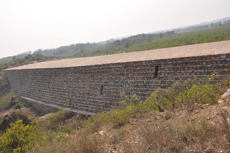
The dam wall comes into view gradually. It does not read like a typical water barrier. It resembles a fortified embankment, set between two low hillocks of the Aravallis.
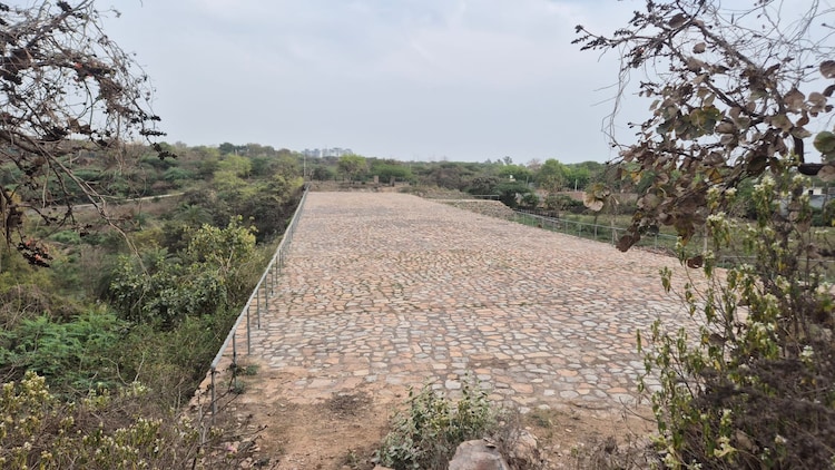
The structure measures about 101 metres in length. The width varies, approximately 19.8 metres at the top and nearly 27.4 metres at the base. In some sections, the wall appears broad and compact, built to hold pressure rather than resist flow.
The height rises to over 10 metres from its base, though the surrounding terrain gives the impression of greater elevation in parts.
Constructed of large stone-masonry blocks, the dam reflects an early method of water control adapted to rocky terrain. The placement between hill slopes allows runoff to collect within a natural basin.
Along the wall are multiple water-release passages, estimated locally at atleast 7 outlets. These include grooved slit-like channels, which appear to have functioned as regulating devices to control the discharge of water, a system that anticipates later hydraulic practices.
Anangpal II has been credited for the foundation and construction of the structure.
The dam is believed to have been built to store water and regulate its flow towards the Surajkund reservoir.
To understand the complete hydraulic structure and the early civilisation in Delhi, we need to learn about the Tomars, who were the first rulers of present day Delhi.
HOW TOMARS MADE DELHI THEIR HOME
The story of Anangpur Dam cannot be told without the story of the Tomars.
References to the Tomars, often also rendered as Tuars, appear across a mix of bardic traditions, colonial-era histories, and later archaeological interpretations. Their origins are layered in both memory and myth.
The British officer and historian James Tod, who spent years documenting Rajput lineages in Rajasthan, wrote in his works that, in the case of the Tuar clan, genealogical certainty was limited and one often had to rely on bardic tradition. He noted that the Bardai tradition linked them to the Pandavas, thereby symbolically connecting them to Indraprastha, the ancient city of the Mahabharata.
Other writers, including Matthew Atmore, drew connections between the Tomars and the legendary lineages associated with Vikramaditya, whose name later became attached to the Vikram Samvat calendar.
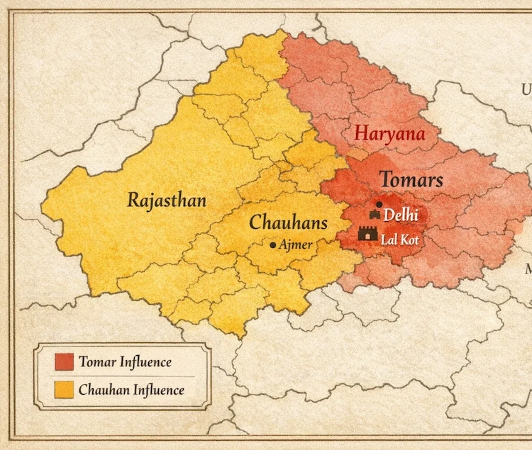
More concretely, Alexander Cunningham, the pioneering archaeologist of colonial India, attempted to connect the later Tomars with the founding of Lal Kot, generally dated to around the 10th century CE, and associated with Anangpal Tomar.
Historians broadly suggest that Tomar groups had already been present in the Haryana-Delhi belt for generations before the formal emergence of Lal Kot. As north-western India came under repeated political pressure and incursions from the west, settlements in the Delhi ridge zone acquired greater strategic importance.
And geography helped.
Delhi’s southern landscape was then marked by rocky ridges, broken hills, natural barriers, and seasonal water channels, a difficult terrain, but also a defensible one. Thanks to the Aravallis, this region could be transformed into a natural fortress.
The remains of Lal Kot, now in south Delhi near the Qutub complex, point to this early phase of urban and military consolidation. Archaeological findings in the region also suggest long-term habitation by both the Tomars and the Chauhans.
Many temple fragments found in and around the Qutub complex are associated with structures built during or before this period.
These areas later became part of the political expansion and consolidation of the Tomar and Chauhan polities. Findings noted by Alexander Cunningham and later historians suggest that Tomar groups had already been settled in the region by around the 6th or 7th century CE.
For roughly four centuries, Tomar rulers held the region, even as north India’s wider political map shifted under the influence of the Gurjara-Pratiharas, Palas, and Rashtrakutas, the great tripartite struggle that shaped early medieval India.
The same period saw the development of a cluster of linked constructions: Surajkund reservoir, Anangpur Dam, Lal Kot, Qutub complex and the region of Mehrauli.
Even today, the surviving fort wall at Lal Kot, often linked in ASI records to the later expansion known as Qila Rai Pithora, suggests how the Tomars were shaping a durable political and ecological landscape.
The Tomars eventually lost Delhi to the Chauhans in the 12th century, as Chauhan power expanded across north India.
Historical interpretations suggest that this transition may not have been purely military.
Mathew Atmore Sherring also noted the possibility of a dynastic alliance, writing that the Tomars and Chauhans may have been connected through marriage, with the Chauhan line linked to the family of the last Tomar ruler of Delhi, often identified as Anangpal III.
THE HYDRAULIC STRUCTURE IN THE ARAVALLIS
Anangpur Dam is not just old but built with a sense of geography. Stone blocks quarried from the Aravallis, held together with brick and earth, form a structure designed to control water in a difficult landscape.
Low Aravalli hills rise around the basin, some reaching nearly 100 metres. The slope directs rainwater and runoff towards the settlement of Anangpur village. Locals say this was once a key habitation zone, possibly linked to the Tomar base in the region.
Between 600 and 1200 CE, many such systems emerged across India. Stepwells, tanks, bunds, and reservoirs were built to store and manage water in varied climates.
Sites like Rani ki Vav, Chand Baori, and the Veeranam tank system show a similar approach.
Early Delhi relied on linked systems, hauz, baolis, and embankments, especially in the south-west, where water was uncertain and recharge depended on seasonal flow.
Anangpur appears to have fed into this network, possibly linked to the Surajkund basin.
Rahul Bhadana, 33, who grew up nearby, recalls:
“When we were younger, this place held water almost all year. The flow towards Surajkund was steady. We saw good water levels. Even leopards were common. They never harmed villagers.”
WHAT WE SAW ON THE RIDGE
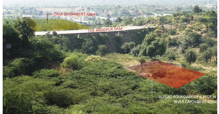
When our team climbed to the top and crossed over to the other side, we spotted a bulldozer cutting into the landscape. It appeared to be levelling land and clearing vegetation.
The moment the machine operators noticed our presence, felt feared, they decided to move away. But the sight was enough to confront us with the larger reality of the Aravallis today: a region under relentless pressure from encroachment, illegal construction, land conversion, and ecological damage.
And that pressure is now pressing directly against one of Delhi’s oldest surviving heritage-water structures.
The dam’s side facing Surajkund contains a series of gates and openings that appear to have been designed for the controlled movement and retention of water.
Stone access points and descending sections along the wall also suggest a functional relationship with water collection and maintenance.
Rahul Bhadana told us that, according to local memory, wooden gates may once have existed at the site and were later replaced or altered with stone during the Sultanate period.
Whether every detail of that oral memory can be archaeologically verified or not, one thing is certain: the structure continued to evolve in use over time.
A VILLAGE MORE HISTORIC THAN THE CITY
The village of Anangpur itself is central to this story.
Locals told India Today that the settlement has existed since at least around 600 AD and the village is one of the oldest in Delhi.
That claim, while needing layered archaeological validation, aligns with the broader pattern of early habitation in the Delhi ridge zone.
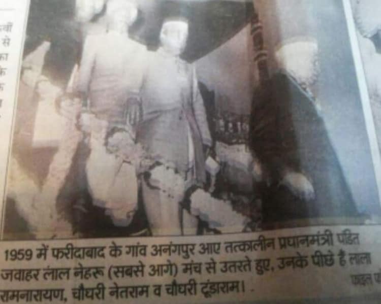
The villagers also recalled a lesser-known but telling historical episode: in 1959, Jawaharlal Nehru is said to have visited Anangpur village, reportedly impressed by the biodiversity of the Aravalli landscape and the cohesion of the local community.
Residents further claimed that plans for the resettlement or restructuring of the village and surrounding communities were discussed in the post-Independence period, but were never fully implemented.
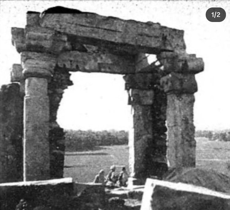
The dam site once also had a Torana-like gateway, believed by locals and some earlier observers to date back to the Tomar period and possibly function as an entrance marker toward the old settlement zone.
That structure has since been moved by the ASI, but older photographs suggest that it stood for centuries.
Delhi’s oldest history is often narrated through its imperial capitals, Mehrauli, Siri, Tughlaqabad, Shahjahanabad, New Delhi.
But much of its earliest, pre-Sultanate civilisational memory lies elsewhere, in villages, ridges, tanks, stone walls, dry channels, and forgotten hydraulic works. Anangpur is one of those places.

The land that once held and distributed water across the Aravallis is now heavily encroached upon.
Concrete structures are spreading across terrain that historically functioned as a natural water-retention and drainage system.
The main dam site itself has not been spared.
In areas close to the site, our team encountered signs of activity that had little to do with heritage or conservation. Several vehicles, including some expensive cars, were parked near the site. Loud music could be heard in an ecologically sensitive zone where such disturbance should not exist.
The place looked less like a protected heritage landscape and more like an informal private leisure spot.
As soon as our presence became known, some of those present appeared uneasy and began asking questions about why we were there.
Given the local sensitivities and the situation on the ground, we chose not to escalate the confrontation and moved on.
The dam and the surrounding village could have been developed as a major example of how traditional water systems once helped communities survive in a region long prone to water stress.
Instead, the site is under pressure from the same forces threatening the wider Aravalli system.
Local revenue records, according to people familiar with the region, indicate that the land value across parts of this Aravalli stretch now runs into hundreds of crores, with estimates touching around Rs 1,000 crore over a wider span of roughly 12 kilometres.
That economic pressure is one of the biggest reasons the landscape is changing so quickly.
And that makes Anangpur more vulnerable than ever.
This is a man-made structure that once supported not only human settlements, but also flora, fauna, water recharge, seasonal ecology, and local livelihoods. At a time when experts repeatedly warn of urban water crises and “Day Zero”-like scenarios in Indian cities, ancient systems such as this are not relics to be admired from a distance.
The Tomars may have ruled from stone walls and hill forts, but they also ruled through water intelligence. Delhi’s buried history is still alive, if we choose to see it. A great part of it remains buried in the Aravallis, beneath present-day settlements, behind damaged plaques, under scrub, stone, dust, and neglect. A hydraulic structure in stone. A memory of the Tomars. A fragment of the Delhi that existed before Delhi became Delhi.
And perhaps also a warning: if such sites are lost, we will not only lose heritage. We will lose older knowledge systems that once made survival possible in this very landscape.
- Ends