

Monsoon 2026: Heavy rain lashes Karnataka and Kerala today. What drove it?
Heavy monsoon rains have lashed Karnataka and Kerala this Saturday. Learn about the science driving this intense weather surge and the seasonal forecast.
")
The southwest monsoon intensifies today with heavy rain lashing Karnataka and Kerala. Here is the science behind the Saturday downpours. (Photo: PTI)

The monsoon engine is roaring to life this Saturday, June 6, as intense moisture surges across the Indian peninsula.
While the season officially commenced over Kerala on June 4, it is today's heavy downpours in Karnataka and Kerala that showcase the true power of this atmospheric system.
THE SCIENCE OF SATURDAY’S DOWNPOURS
At its core, the monsoon is a vast heat engine driven by temperature gradients. During summer, the Indian landmass absorbs solar energy significantly faster than the surrounding Indian Ocean.
This differential heating creates a low-pressure area, a region where air is lighter and ascends.
This acts like a giant vacuum, drawing moisture-laden winds from the high-pressure ocean regions inland.
When these winds encounter the Western Ghats, they are forced to rise, cool, and condense, resulting in the heavy orographic rainfall we are witnessing today.
A cyclonic circulation currently stationed off the coast of Karnataka is acting as an intensifier, dragging more moisture into the southern states.
This is precisely why regions like Dakshina Kannada and Udupi recorded staggering rainfall totals exceeding 100 millimetres overnight.
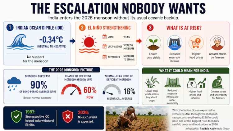
THE EL NINO CHALLENGE
Even as the rain falls, we must consider the broader climate context. This year, the monsoon is battling the influence of El Nino, a phenomenon where surface waters in the central and eastern Pacific Ocean become unusually warm.
This warming disrupts global wind patterns, often acting as a spoiler for Indian rainfall.
Forecasters at the India Meteorological Department (IMD) note that while the current monsoon surge is vigorous, the seasonal outlook remains cautious, with total rainfall potentially hovering around 90 to 92 per cent of the long-term average.
As the monsoon continues its northward march, the interaction between this active surge and the underlying climatic constraints will determine the season's final yield.
For now, the focus remains on the immediate heavy rain alerts across southern and northeastern India, where the monsoon is finally making its mark.
- Ends