Watch: Rare tornado hits Akhnoor. Science behind Jammu's unusual spring twister
Watch the rare landspout tornado that stunned residents in Akhnoor, Jammu, on April 11. Know how it forms, and the science behind the atmospheric triggers.
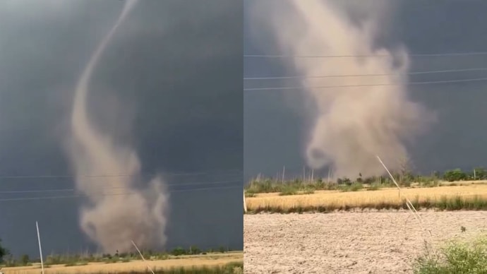
The atmosphere over Akhnoor, Jammu, performed a rare and violent dance on the evening of April 11, 2026.
While the rest of the country began to simmer under a rising Sun, a dark, rotating column of dust and wind touched down near Devipur, marking one of the most unusual weather events in the region’s history.
For nearly 10 minutes, the vortex stretched from the ground to the clouds, a sight far more common in the plains of America than the foothills of the Himalayas.
The vortex of a tornado is a rapidly rotating column of air, extending from a thunderstorm to the ground, formed by air swirling around a central axis.
Meteorologists identified the event as a landspout tornado.
SCIENCE BEHIND LANDSPOUT TORNADO THAT HIT JAMMU
The phenomenon spotted in Jammu is called a landspout tornado because the narrow, twisting column of the storm looks remarkably like the spout of a kettle.
Unlike the massive supercell tornadoes often seen in films, a landspout forms while the thunderstorm is still growing.
A supercell tornado builds from the cloud down to the ground like a descending funnel, while a landspout builds from the ground up.
Traditional twisters are born from a pre-existing rotation high up in a mature storm cloud, whereas a landspout begins as a shallow spinning motion near the ground that is suddenly stretched upward by a developing updraught, or the rising air of a developing storm.
The catalyst for this event was a compact but potent Western Disturbance.
This weather system created high CAPE, which stands for Convective Available Potential Energy.
You can think of CAPE as atmospheric fuel; the more energy there is, the faster the air rises.
When this rising air meets wind shear, which is the change in wind speed and direction at different heights, the air begins to spin into a towering vortex.
WHY DID A TORNADO FORM IN JAMMU?
India is no stranger to extreme weather, but tornadoes are typically reserved for eastern states like West Bengal and Odisha.
Jammu and Kashmir almost never sees such phenomena because the mountainous terrain usually breaks up the specific wind patterns needed for rotation.
However, this is already the second such “twister” reported in the region this spring, following a similar occurrence that startled locals just weeks ago.
This specific vortex was born from a perfect, brief alignment of moisture and instability.
According to Dr Mukhtar Ahmad, the Director of the J&K Meteorological Department, the event was triggered by a squall line from thunderstorm cells that developed rapidly.
Despite the dramatic footage captured by locals showing the funnel twisting near the Pakistan border, no injuries were reported.
It was a vivid reminder that the atmosphere still holds the power to surprise us with local, high-intensity events.
The atmosphere over Akhnoor, Jammu, performed a rare and violent dance on the evening of April 11, 2026.
While the rest of the country began to simmer under a rising Sun, a dark, rotating column of dust and wind touched down near Devipur, marking one of the most unusual weather events in the region’s history.
For nearly 10 minutes, the vortex stretched from the ground to the clouds, a sight far more common in the plains of America than the foothills of the Himalayas.
The vortex of a tornado is a rapidly rotating column of air, extending from a thunderstorm to the ground, formed by air swirling around a central axis.
Meteorologists identified the event as a landspout tornado.
SCIENCE BEHIND LANDSPOUT TORNADO THAT HIT JAMMU
The phenomenon spotted in Jammu is called a landspout tornado because the narrow, twisting column of the storm looks remarkably like the spout of a kettle.
Unlike the massive supercell tornadoes often seen in films, a landspout forms while the thunderstorm is still growing.
A supercell tornado builds from the cloud down to the ground like a descending funnel, while a landspout builds from the ground up.
Traditional twisters are born from a pre-existing rotation high up in a mature storm cloud, whereas a landspout begins as a shallow spinning motion near the ground that is suddenly stretched upward by a developing updraught, or the rising air of a developing storm.
The catalyst for this event was a compact but potent Western Disturbance.
This weather system created high CAPE, which stands for Convective Available Potential Energy.
You can think of CAPE as atmospheric fuel; the more energy there is, the faster the air rises.
When this rising air meets wind shear, which is the change in wind speed and direction at different heights, the air begins to spin into a towering vortex.
WHY DID A TORNADO FORM IN JAMMU?
India is no stranger to extreme weather, but tornadoes are typically reserved for eastern states like West Bengal and Odisha.
Jammu and Kashmir almost never sees such phenomena because the mountainous terrain usually breaks up the specific wind patterns needed for rotation.
However, this is already the second such “twister” reported in the region this spring, following a similar occurrence that startled locals just weeks ago.
This specific vortex was born from a perfect, brief alignment of moisture and instability.
According to Dr Mukhtar Ahmad, the Director of the J&K Meteorological Department, the event was triggered by a squall line from thunderstorm cells that developed rapidly.
Despite the dramatic footage captured by locals showing the funnel twisting near the Pakistan border, no injuries were reported.
It was a vivid reminder that the atmosphere still holds the power to surprise us with local, high-intensity events.

