1,000 km wide El Nino build up: Massive wall of warm water seen in Pacific Ocean
2026 has seen several predictions of an intense El Nino event later this year. That prediction is now growing more credible each day as meteorologists from around the world begin to notice the telling signs. Here's a new one.
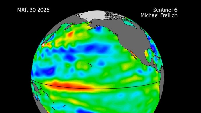
A wall of warm water is moving across the Pacific Ocean, and a satellite has been watching it travel in real time.
Scientists say what they are seeing is a strong early signal that an El Nino weather event is building, one that could impact rainfall patterns and temperatures across large parts of the world, including India, later this year.
IS EL NINO COMING SOON?
El Nino in 2026 has been a trending headline, with several predictions of an intense El Nino event later this year. That prediction is now growing more credible each day as meteorologists from around the world begin to notice the telling signs.
Just days ago, Australia’s Bureau of Meteorology (BOM), a globally respected watcher of Pacific Ocean related weather developments, said that El Nino is likely to arrive by June.
This time, a clue signalling the arrival of El Nino was caught in real time by a Nasa-European satellite.
The Sentinel-6 Michael Freilich satellite, launched in 2020 by Nasa and led by the European Space Agency (ESA) as part of the EU's Copernicus Programme, measures and maps water height across the entire ocean every 10 days, down to fractions of an inch.
By tracking subtle changes in sea level, the advanced satellite can effectively read the ocean's temperature, because warmer water expands and sits physically higher.
OCEAN'S EARLY WARNING
What the satellite spotted this time is called a Kelvin wave, which is a massive underwater swell of warm water that travels eastward along the equator.
These waves form after winds over the far western Pacific temporarily shift direction, causing water in the western tropics to warm and sea levels to rise. The wave then moves east over several weeks, eventually warming the waters off the coast of South America.
El Nino develops as multiple such waves arrive over several months, and warm water accumulates off the coasts of Colombia, Ecuador, and Peru, creating ripples felt around the world in the form of erratic and dry weather conditions.
Sentinel-6's measurements show a small Kelvin wave forming in late January before fading away. A fresh wave emerged in early March, drifted east, and by mid-May, seas around Peru were more than 15 centimetres higher than long-term averages.
The pattern is clear and obvious.
"While this year's event started a bit later than the big El Ninos of 2015 and 1997, it's beginning to catch up," said Josh Willis, sea level researcher at Nasa's Jet Propulsion Laboratory (JPL) and project scientist for the mission. "We'll see how big it gets."
SHOULD WE BE WORRIED ABOUT EL NINO?
El Nino is not just a Pacific Ocean story.
Warmer sea surface temperatures in the central and eastern Pacific shift the jet stream, affecting storms and altering rainfall patterns worldwide. In more modest events, impacts like drought and flooding stay mostly in and around the tropical Pacific.
Historically, strong El Nino years have also been associated with weakening of the Indian monsoon, which can hit agriculture and water availability hard across the subcontinent. That's bound to compound issues like extreme heat and water scarcity that India is already facing.
El Ninos typically peak between November and January, meaning the full scale of the impacts won't be clear for several months yet.
"Every El Nino is different," said JPL researcher Severine Fournier, deputy project scientist for the mission. "But they almost always make for a hot year and big changes in rainfall in parts of the globe."
A wall of warm water is moving across the Pacific Ocean, and a satellite has been watching it travel in real time.
Scientists say what they are seeing is a strong early signal that an El Nino weather event is building, one that could impact rainfall patterns and temperatures across large parts of the world, including India, later this year.
IS EL NINO COMING SOON?
El Nino in 2026 has been a trending headline, with several predictions of an intense El Nino event later this year. That prediction is now growing more credible each day as meteorologists from around the world begin to notice the telling signs.
Just days ago, Australia’s Bureau of Meteorology (BOM), a globally respected watcher of Pacific Ocean related weather developments, said that El Nino is likely to arrive by June.
This time, a clue signalling the arrival of El Nino was caught in real time by a Nasa-European satellite.
The Sentinel-6 Michael Freilich satellite, launched in 2020 by Nasa and led by the European Space Agency (ESA) as part of the EU's Copernicus Programme, measures and maps water height across the entire ocean every 10 days, down to fractions of an inch.
By tracking subtle changes in sea level, the advanced satellite can effectively read the ocean's temperature, because warmer water expands and sits physically higher.
OCEAN'S EARLY WARNING
What the satellite spotted this time is called a Kelvin wave, which is a massive underwater swell of warm water that travels eastward along the equator.
These waves form after winds over the far western Pacific temporarily shift direction, causing water in the western tropics to warm and sea levels to rise. The wave then moves east over several weeks, eventually warming the waters off the coast of South America.
El Nino develops as multiple such waves arrive over several months, and warm water accumulates off the coasts of Colombia, Ecuador, and Peru, creating ripples felt around the world in the form of erratic and dry weather conditions.
Sentinel-6's measurements show a small Kelvin wave forming in late January before fading away. A fresh wave emerged in early March, drifted east, and by mid-May, seas around Peru were more than 15 centimetres higher than long-term averages.
The pattern is clear and obvious.
"While this year's event started a bit later than the big El Ninos of 2015 and 1997, it's beginning to catch up," said Josh Willis, sea level researcher at Nasa's Jet Propulsion Laboratory (JPL) and project scientist for the mission. "We'll see how big it gets."
SHOULD WE BE WORRIED ABOUT EL NINO?
El Nino is not just a Pacific Ocean story.
Warmer sea surface temperatures in the central and eastern Pacific shift the jet stream, affecting storms and altering rainfall patterns worldwide. In more modest events, impacts like drought and flooding stay mostly in and around the tropical Pacific.
Historically, strong El Nino years have also been associated with weakening of the Indian monsoon, which can hit agriculture and water availability hard across the subcontinent. That's bound to compound issues like extreme heat and water scarcity that India is already facing.
El Ninos typically peak between November and January, meaning the full scale of the impacts won't be clear for several months yet.
"Every El Nino is different," said JPL researcher Severine Fournier, deputy project scientist for the mission. "But they almost always make for a hot year and big changes in rainfall in parts of the globe."

