
India's weather whiplash: Deadly heatwave in plains, sudden snowfall in Himalayas
Snow has returned to parts of the upper Himalayas even as northern and central India remain in a severe heatwave. The split forecast underlines a volatile seasonal transition, with storms, hail and heavy rain unfolding elsewhere.
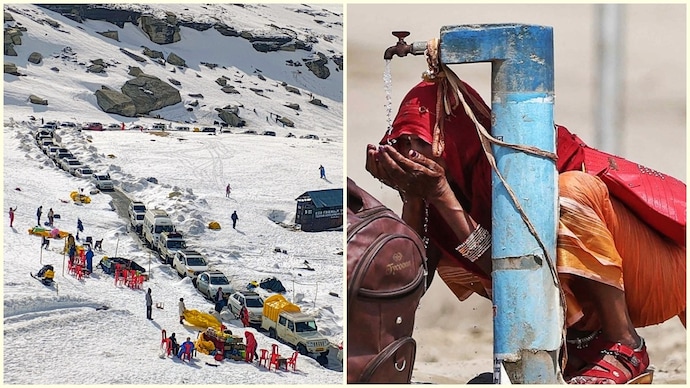

India is currently witnessing a dramatic weather divide, with snowfall returning to the upper Himalayas even as large parts of northern and central India remain trapped in a relentless heatwave.
Fresh snow has been reported around Zoji La, parts of Ladakh, and higher reaches of Jammu and Kashmir, creating striking scenes of white mountain passes at a time when plains below are sweltering under extreme temperatures.
The contrast highlights what meteorologists describe as a “weather whiplash” unfolding across the country.
WEATHER GOES FOR A TOSS IN INDIA
While cold winds and western disturbances are keeping the Himalayan region unstable, vast parts of northwest, central and northern India continue to bake under persistent heat. Cities across Rajasthan, Delhi, Haryana, Uttar Pradesh and Madhya Pradesh have been recording punishing daytime temperatures, with warm nights offering little relief.
The latest forecast from the India Meteorological Department shows that India’s weather systems are pulling the country in opposite directions at the same time.
In the Himalayas, intermittent rain, thunderstorms and snowfall in higher reaches are being driven by active western disturbances.
The IMD has forecast scattered rainfall and thunderstorms over Jammu and Kashmir, Himachal Pradesh and Uttarakhand through the coming week, along with hailstorms and powerful winds reaching up to 70 kmph in some areas by May 28 and 29.
At the same time, heat continues to dominate the plains because there has been no widespread, sustained rain system strong enough to break the cycle. Even where storms are expected, they are likely to be isolated and short-lived, meaning temperatures can quickly rise again after brief relief.
The weather contrast becomes even sharper when looking east and south. The northeast is bracing for extremely heavy rainfall, especially over Assam and Meghalaya on May 25, with more heavy rain forecast through the week across Arunachal Pradesh, Nagaland, Manipur, Mizoram and Tripura. Sub-Himalayan West Bengal and Sikkim are also likely to see repeated spells of rain and thunderstorms.
Meanwhile, southern India is moving toward an active pre-monsoon phase. Kerala, coastal Karnataka, Tamil Nadu and parts of Telangana and Andhra Pradesh are expected to receive widespread rainfall, thunderstorms and gusty winds through May 29. Some regions could also witness thundersqualls with wind speeds touching 70 kmph and isolated hailstorms.
WHY IS INDIA WITNESSING WEATHER WHIPLASH?
Meteorologists say this sharp contrast is a sign of India entering a turbulent seasonal transition period, where winter-like systems still affect the mountains while intense summer heat dominates the plains ahead of the southwest monsoon’s advance.
India is witnessing “weather whiplash” because multiple weather systems are colliding at the same time. Western disturbances moving across the Himalayas are bringing rain, thunderstorms and even snowfall to higher reaches of Ladakh and Jammu & Kashmir.
Meanwhile, much of northern and central India remains under strong dry heat conditions, trapping cities in an intense heatwave cycle. At the same time, moisture from the Bay of Bengal and Arabian Sea is triggering heavy rain and thunderstorms in the Northeast and southern states. This sharp clash between cold mountain weather, pre-monsoon storms and extreme summer heat is creating dramatic contrasts across the country.
For millions living in heatwave-hit regions, however, the immediate reality remains unforgiving with blistering afternoons, dangerously hot nights and no sign yet of a lasting cooldown.